Erosion, Evapotranspiration, and Gopher Football

eroded banks 1 featured
Eroding banks on a Minnesota River tributary. Much of the soil that is filling in Lake Pepin comes from such erosion.

When the University of Minnesota’s Golden Gophers football team played its first game in 1882 (beating Hamline University 4-0), less than 100,000 tons of sediment washed into Lake Pepin each year, mostly eroded from the banks of the Minnesota River and its tributaries.

By the time the Gophers won their last national championship, in 1960, the amount had doubled.

And in 2009, when they played their first game in TCF Bank Stadium, five times the historic amount of soil was washing away from stream banks each year.

Excess suspended sediment in the Mississippi River at its confluence with the St. Croix. Eighty percent of the sediment here is from the Minnesota River. Turbidity is a serious water quality impairment.
blue earth river widening aerial
Eroding banks on a Minnesota River tributary. Much of the soil that is filling in Lake Pepin comes from such erosion.

More soil is being eroded from the banks because more water is flowing down the region’s rivers. Greater flows are carving a wider channel, carrying soil from the banks and bluffs. This means muddy rivers that are choking aquatic life.

Not good. But why is there more water in many of Minnesota’s rivers?

Research Station scientist Shawn Schottler has chased the question of where all the extra dirt is coming from over the past decade. In peer-reviewed research, Schottler and colleagues have found that modern agriculture practices have radically disrupted the invisible and important process called “evapotranspiration.”

When rain falls on Minnesota, most of it goes right back to the sky. It flows into ponds and wetlands and evaporates. Plants suck it up and “breathe it out” into the atmosphere as vapor – something called transpiration.

It used to, anyway. When the land is covered with vegetation, more than three-quarters of the rain that falls rises back to the sky through evaporation or plant transpiration. When the land isn’t covered with vegetation, that just doesn’t happen.

Over the past 134 years, not only has the University of Minnesota football team’s fortunes risen and fallen, and not only has the amount of water flowing down the Minnesota River quintupled, the landscape has gone from thick prairie sod to bare soil covered with crops for a few months each year.

One of the major changes is the conversion of cropland to soybeans, which started in the 1940s.

crop conversion

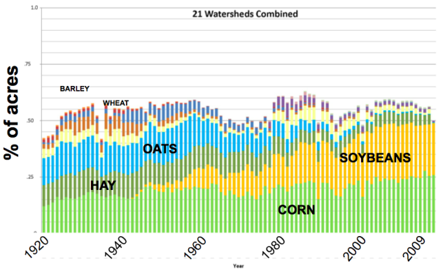
“Soybeans aren’t even planted until May,” Schottler says. “All spring, the fields are bare, and evapotranspiration is not happening.” Historically, common crops like alfalfa were growing and using water right away in May.

Schottler compares it to a personal budget. There is income – precipitation, a paycheck – and expenses – evapotranspiration, a mortgage. What comes in eventually goes out. But whether it returns to the atmosphere as vapor or runs off into rivers makes a big difference downstream.

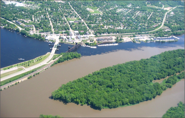
Flow in one of the major tributaries of the Minnesota, the Cottonwood, has increased by 75 percent since 1940. That’s why two-thirds of the sediment that is filling in Lake Pepin comes from the streambanks and not the farm fields.

Not only are there growing things on the land a lot less of the year, innumerable low places where water might be trapped long enough to evaporate have been eliminated by drain tile and other methods.

“You used to have depressions on the landscape where the water flowed into and evaporated away, now we’ve gotten rid of with drainage,” says Schottler.

Precipitation has also increased in the region in the last century. Minnesota’s changing climate has caused greater rainfall – and has allowed scientists to see what river flow is caused by more precipitation, and what is caused by less evapotranspiration. The higher flows are simply not proportional to the rise in rainfall.

Most importantly, the average annual rainfall has not happened evenly over the year. Analyzing rainfall and streamflow records, Schottler and his colleagues can see that the largest increases in river flows occurred in the months of May and June. In many watersheds, there has been no significant change in the spring and early summer. The largest rainfall increases have happened in fall.

gopher football losing percent
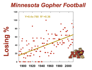
This has all added up to more water in the rivers, more erosion of streambanks, and more soil in the water. The Golden Gophers, of course, have nothing to do with it.

The wins and losses of University of Minnesota football have absolutely no effect on sediment loads, even though their loss percentage has increased at a rate nearly identical to the loss of soil from stream banks.

Correlation is not causation, as they say. But factors like increased precipitation also haven’t had appreciable effects, while other big changes on the landscape have drastically changed the very width of our rivers.


Asking ‘What If’ in the St. Croix Watershed

st croix algae
Noxious algae bloom on the St. Croix River at its confluence with the Kinnickinnic River, August 2011.

There are lots of things farmers can do to clean up the water flowing into Lake St. Croix on the Minnesota-Wisconsin border. Popular practices include buffer strips, smart tillage, and cover crops.

The more complicated question is which projects are most worth the effort.

What to do where – to have the biggest impact for the lowest investment – has important implications for improving the water quality of the federally-protected river. Research Station scientist Jim Almendinger has been wrestling with that question, thanks to funding included in the St. Croix Crossing in Stillwater.

“In the face of commodity prices and government policies that encourage planting more corn and soybeans, and development resulting from the new bridge at Stillwater, Lake St. Croix will likely degrade further without efforts at curbing phosphorus loads from all sources,” Almendinger says.

Further degradation is unacceptable. Minnesota and Wisconsin actually want to cut phosphorus in Lake St. Croix by 27 percent – to 360 tons/year, the same level as existed in the 1940s – by 2020. Efforts to curb phosphorus are underway across the watershed. Ensuring those efforts are effective is where computer models comes in.

Simulating the St. Croix

model components
The many factors that determine how a watershed and a model work.

Almendinger has developed a model of the watershed meant to serve as a tool for people and organizations working across two states, 19 counties, and other jurisdictions. It will help paint the big picture, and put local efforts in context.

The project essentially provides a way to answer “what if we do X upstream? How will it help or hurt Lake St. Croix?”

Because agriculture is the biggest source of sediment and phosphorus that is flowing into Lake St. Croix, Almendinger has been studying how changes in farm practices have the potential to improve the situation. Covering soil with another crop between harvesting and planting corn or soybeans is the clear winner.

Winter crops works best

fall cover crops edit
Winter wheat planted in the fall amid corn stubble.

Almendinger plugged winter wheat as a cover crop into the model (although he says any crop that can become well established by December will work), and found it would provide the biggest bang for the buck – reducing phosphorus in Lake St. Croix by 23 percent if implemented on every acre planted with corn and soybeans in the watershed. Buffer strips and grassed waterways are also promising, with the capability of reducing by 15 percent the amount of phosphorus running off a field.

“When large portions of the landscape that were formerly tilled and protected only by scattered crop residue are replaced with living cover crops during the fall and through the spring runoff season, sediment and nutrients in runoff will decline substantially,” Almendinger says.

The algorithms are part of a computer program called SWAT – the Soil and Water Assessment Tool. By entering data like about whether an area is residential, agricultural, wetlands, or other land types, the steepness of slopes, and the types of soil, the interconnected watershed can be translated into a reasonably reliable pile of computer code.

Nothing can match the real-world, though, Almendinger hastens to point out. Despite imperfections, models have an essential job.

“Models are not totally wrong or right, we have to live in the uncertain reality in between,” he says.

An achievable challenge

st croix basin model calibrated
Calibrating the model to data collected from the St. Croix makes for a pretty accurate representation of the river.

The model took years to fine-tune, matching computer predictions with real-world measurements. The result was the news that hitting cleanup goals will be a big challenge. “If we do everything possible on the landscape, we should get close to the goal,” he says.

The reality is that an “all-of-the-above approach” is needed to reduce phosphorus in Lake St. Croix, decreasing the danger of toxic algae blooms and the overall fouling of the water. But the software also pointed to some of the most effective methods.

Making such major changes to the landscape and farming practices may seem intimidating, but the alternative is not an option either: worsening water quality in Lake St. Croix, algae and other impacts having highly negative effects on people, fish, and other wildlife.

Red Lakes Research Could Reveal Connections Between Climate, Nutrients, and Water Quality

This slideshow requires JavaScript.

A new study underway by Research Station scientists seeks a familiar objective in a unique new locale. In partnership with the Red Lake Band of Chippewa Indians, they will reconstruct the history of Upper and Lower Red Lakes – with a combined size of 288,000 acres, the largest water body entirely in the borders of Minnesota, and with a unique history and watershed – using techniques the Station’s staff developed over the past 20 years.

Extracting sediment cores from the bottom of the lake and analyzing the mud will provide essential data about the water quality and how the lake has worked for the past 200 years.

Combined with intensive water quality monitoring that the Red Lake Nation Department of Natural Resources has conducted since 1990, this work will reveal natural cycles and human impacts, to help better protect and manage the lake in the future.

“We are really interested in learning whether the nutrient dynamics of the lake have shifted since the area was settled by Europeans and using that information to establish baselines for water quality goals,” said Shane Bowe of the Red Lake Department of Natural Resources.

Comparative studies

Some of the key factors that affect the Red Lakes are shared by another current Research Station study, Lake of the Woods, 50 miles farther north. While there are similarities, such as shallow waters over the sand and clay bed of ancient Glacial Lake Agassiz and plentiful peatlands in the watershed, the Red Lakes are unusual in their condition, management, past – and solitude.

Scientists Mark Edlund and Adam Heathcote, with the assistance of Bowe and staff of the Red Lake Department of Natural Resources, made the first foray into the field in March, crossing vast expanses of ice and snow in a vehicle that looks like nothing so much as a Star Trek shuttlecraft. With only fleeting glances of a pack of timber wolves to keep them company, the lake felt as empty as deep space, too.

“Once we got off the landing, all we saw were wolves,” Mark says. “We didn’t cross a snowmobile track, or see a fish house.”

In two days, the group took cores from six locations on the lakes, racking up nearly 50 miles of travel on the ice while motoring between sites.

uodrd02bxl49a

Two key factors that control water quality have emerged on Lake of the Woods to the north: the lingering effects of a flood of sawdust and wastewater that was dumped in the Rainy River – the lake’s largest tributary – for several decades, as well as the role of a changing climate. But the Red Lakes never had a major “pulse” of pollution in the past, providing a perfect opportunity to contrast the roles of past pollution and climate change in what Mark calls the “nastification” of large shallow lakes.

Rainfall, warmer weather, and unnatural nutrients

Understanding the effects of climate and nutrient pollution is essential if Minnesotans want healthy lakes in the decades ahead.

Also like Lake of the Woods, the Red Lakes are characterized by darkly stained water flowing out of the vast bogs of the Red Lake Peatlands. Those bogs have not historically sent much phosphorus downstream, so consequently lakes in this region may be even more susceptible to small changes in their watersheds.

“In regions like southwestern Minnesota, where lakes are already polluted with nutrients, increasing phosphorus by five parts per billion may not cause a noticeable change,” Adam says. “But in low-impact systems it may completely shift how the lakes function.”

Climate change could easily bump up the amount of phosphorus flowing out of the bog through changes in hydrology, chemistry, and organic matter decomposition.

There is only one way to find out what is going on, and it started with venturing onto the deserted ice, which Mark compared to the high Arctic landscapes where he has worked in the past.

Alone on the lakes

red-lake-driving-external

The first day in the field was on Lower Red Lake. The sky was blue, the ice was bright, and it was beautiful. The second day, snow started right after they set off. Pretty soon they could see only what was 100 feet in front of them. They traveled by GPS, eyes glued to the windshield, hoping they didn’t hit any invisible pressure ridges.

Besides the weather those two days, the Red Lakes also contrast with each other in another important way: the lower lake is about twice as deep as the upper. And most summers, bright green algae blooms appear on the shallower upper lake.

Depth has a complex relationship with algae and climate change. In a shallower lake, winds can more easily push waves and stir up bottom sediments. This can constantly return phosphorus to the water that had settled to the bottom.

Connecting water depth and quality

Most significantly, depth determines how lake waters separate into colder and warmer layers – with lower oxygen levels on the bottom. A shallow lake might stratify briefly several times over the course of a summer and then, when the wind picks up, the waters are mixed together, and a bunch of nutrients are brought to the sunny and fertile top waters.

The difference in average depth on the two lakes should help the scientists determine how wind and stratification work to recycle or sequester nutrients in both lakes. This could be helpful for protecting waters across the state.

“Upper and Lower Red Lakes are big shallow lakes that may be suffering the same problems that many other big shallow lakes in Minnesota have,” Mark says.

Studying these two massive and somewhat mysterious bodies of water will not only support the environmental management goals of the Red Lake Nation, but also provide valuable insights about how Minnesota’s shallow northern lakes will respond into the future.

Zombie Phosphorus: The Long-Term Consequences of Nutrient-Rich Runoff

Robert@GlacialLakes
Robert Dietz with a sediment core from Baby Lake in Glacial Lakes State Park, western Minnesota. (Photo by Dan Engstrom)

Imagine a lake full of fish and frogs and waterfowl. Surrounded by fields and forests. Blue sky reflected in the water. Kids swimming in it.

One summer, the lake starts turning green. Scientists discover too much nutrient-rich runoff is feeding algae blooms, some of which are poisonous to people and animals. The food web is disrupted, the fishing suffers, and nobody wants to put a toe in the water.

So septic systems are upgraded, rain gardens and buffer strips installed, and best management practices put to work on agricultural lands upstream. Runoff slows down and more soil and nutrients stay on the land. Algae has less phosphorus and nitrogen to eat, and noxious blooms shrink.

Right? Not necessarily.

In lakes throughout the upper Midwest, from giant Lake of the Woods to dozens of smaller lakes in our urban and agricultural landscapes, clean water has not obviously followed pollution reductions. It can be a big disappointment.

It doesn’t mean the watershed cleanup has been a waste. If runoff was not reduced now, the lakes would never recover. But the complex connections between land, water, climate, chemistry, algae, and even carp can conspire to make us pay a high price for past sins.

It also makes accurately predicting how long it will take for a lake to improve a very vexing question.

Reincarnated phosphorus

The key factor in such stubborn lakes is whether or not phosphorus that was washed in years or decades ago is caught in a cycle of temporary burial and resurrection. If phosphorus isn’t permanently buried by sediments, or carried away by lake outflow, it can live on a long time.

Phosphorus in water readily enters the food chain, where it is taken up by algae which eventually die and fall to the bottom, releasing the phosphorus as it decomposes. Depending on conditions at the bottom of the lake, the phosphorus is either buried as new sediments accumulate on top, or released back to the lake water.

Doctoral researcher Robert Dietz, working with Dr. Dan Engstrom, the research station’s director, as his advisor, is undertaking an ambitious effort to figure out where phosphorus mobility happens and where it doesn’t ­– and why. The study could be said to have started more than 20 years ago, when Engstrom collected sediment cores from lakes around the state – and recorded the locations’ GPS coordinates. Now, Dietz has returned to some of those same spots and taken new cores to compare with the old ones to see if the phosphorus deposited in the past was staying put or instead has migrated to near the top, where it can be easily recycled into the lake.

“We were able to quantify the degree of phosphorus mobility in an actual field setting, where most other studies have been based on short-term lab experiments or models,” Dietz said. The evidence this project is collecting will be highly valuable in setting more accurate expectations about how long it could take a lake to recover from nutrient pollution.

It better be useful, because Dietz has dedicated many long days and nights in the laboratory –by his count, more than 900 hours. He napped on a couch or in his car on several occasions. To extract and measure phosphorus from 1,200 sediment samples, Dietz calculates he made more than 8,000 liquid transfers – that’s about 22,000 pipette squeezes.

Metals, depth, and carp

But finally, some patterns are emerging. For one thing, two common metals in the sediments have very different effects. Iron binds to phosphorus, but in a low-oxygen environment like the bottom of a lake, releases it back into the water. In contrast, aluminum also chemically binds to phosphorus, but does not release it when bottom waters become anoxic. The ratios of these materials in the sediments depend on the area’s geology, while oxygen conditions depend on how long a lake stratifies during summer, how much algae is produced at the lake surface, and how rapidly oxygen in bottom waters is depleted as the algae dies, sinks, and decomposes.

These are the conditions that Dietz and Engstrom’s study is seeking to understand. “It’s like we’re working on a big jigsaw puzzle, but the dog ate an important piece. We’re trying to get him to regurgitate it,” Dietz says.

The depth of the lake, and even the fish in it, can also affect how much phosphorus gets reused. Both factors basically determine how much the bottom sediments get disturbed. The bottom of a shallow lake is much more affected by wave and wind action than the sediments in a deep lake. Non-native carp, nosing through the muck of a shallow lake, can also keep it stirred up.

Dietz is in the midst of analyzing his vast real-world data, which will hopefully reveal much more about how phosphorus moves around in the mud. Figuring this out will be what Engstrom calls a “keystone for being able to predict the timeframe of lake recovery.”

Whatever is learned about how long it might take lakes to be free of the effects of excess phosphorus, Engstrom also points out another important lesson: nutrient pollution has long-term consequences. “it’s a lot easier to keep lakes clean in the first place than to fix them after they’re damaged.”

Pine Needles Artists-in-Residence Selected for 2016 Season

IMG_20160312_174631145_HDR

The St. Croix Watershed Research Station has selected five artists to live and work at its historic Pine Needles cabin this summer. The artists and writers will each spend two to four weeks at the cabin on the banks of the St. Croix River.

This year mark’s the residency’s fifteenth anniversary. Since 2001, the program has provided dedicated time and space for participants to pursue artistic interests. It also lets artists interact with Research Station scientists and the community, informing their creative process.

The 2016 artists-in-residence are: Kim Roberts (Washington, D.C.), Gary Noren and Marty Harding (Chisago City, MN), Marly Beyer (Portland, OR), and C.B. Sherlock (Minneapolis MN).

The program received a nearly record number of applications from around the United States this year. Applications were reviewed by station staff and outside judges.

screen-shot-2015-02-24-at-8-46-09-am

Kim Roberts is an award-winning poet and literary historian. Her most recent collection of poems, Fortune’s Favor: Scott in Antarctica, is a series of connected blank verse sonnets in the voice of Antarctic explorer Robert Falcon Scott. Her forthcoming book, The Scientific Method, includes poems about scientists such as Thomas Alva Edison, Nikola Tesla, Ernst Haeckel, and Carl Sagan.

“I like poems that are firmly rooted: in a specific place, a historic time period, or in the voice of a particular person,” Roberts said.

THE INVASIVE WEED SYNDICATE, by Kim Roberts

Shepherd’s Purse

A rude ring of lobed leaves cling
to the bottom of the stem, and from this stage
the actors rise in heart-shaped pods
and strip to white petticoats by the open road.

Continue reading →

13-IMG_8642
Photo by Gary Noren

Gary Noren and Marty Harding are collaborating on a project of photography and choral music that will celebrate the St. Croix River. Noren will document the river and work of scientists studying the river in photography; Harding will curate choral music relating to rivers and produce a community concert later in the year.

“We feel a deep sense of urgency to take time out from professional and community commitments this year to reflect on the meaning of this spectacular river in our midst,” Noren and Harding said.

6_Oregon Tidepools
Illustration by Marly Beyer

Marly Beyer is an artist and scientific illustrator. Recent work includes illustrations of the Oregon Tidepools and the John Day Fossil Beds. She will study the flora and fauna of the river valley and create a series of educational paintings.

“A chance to connect with local scientists and to study specimens and ecology of the area is an amazing opportunity that will ultimately lead to the creation of more relevant and more successful paintings,” Beyer said.

04 Sweet Grass Ra copy
Sweet Grass, by C.B. Sherlock

C.B. Sherlock is a print maker and book artist, who creates small edition books and one-of-a-kind works of art. Her work combines text, imagery and nontraditional housing. She hopes to create an artist’s book in response to the science of the St. Croix River.

“My work is about the threads that connect us: connections to the land, to our past, and to each other,” Sherlock says.

The Pine Needles cabin was originally built in 1912 by conservationist J.W.G. Dunn and was later owned by his son James Taylor Dunn, who served as chief librarian of the Minnesota Historical Society from 1955 to 1972 and published the first major history of the St. Croix River in 1965. It was donated to the St. Croix Watershed Research Station in 1998, the Pine Needles residency was piloted by writer Laurie Allmann in 2001, and was opened up to other artists starting in 2002.

Pine Needles artist shows work in Marine; featured in magazine

“The St Croix River flows through the body of work. The river and its tributaries carve out and define the land. The roads move us along it, the rail lines follow it, the bluffs were sculpted by it, and towns develop alongside it.” – Painter Joshua Cunningham

This slideshow requires JavaScript.

Oil paintings of the St. Croix River by Joshua Cunningham are now on display at Christ Lutheran Church in Marine on St. Croix, until April 22. The works were all created based on Cunningham’s two-week stay last summer on the banks of the river at the historic Pine Needles Cabin, an artist-in-residency program operated by the St. Croix Watershed Research Station.

St. Paul-based Cunningham says the residency gave him understanding and appreciation of the river that went much deeper than its appearance and aesthetics. Even though he works in a visual medium, natural history, science, and close study gives his images their meaning.

Cunningham’s residency was recently featured in Plein Air magazine, a national publication for painters that work outside.

“While the light, season, and prevailing weather set the palette, tone, and mood in my work, my curiosity about the natural history of a place set the subject of that palette,” Cunningham wrote.

This new show is dedicated to the paintings created in the field during his residency and some larger studio pieces created afterwards.

During his residency, Cunningham immersed himself in his work, creating paintings nearly every day.Local artist Tom Maakestad took Cunningham out to a few of his favorite spots to paint on the St. Croix River from Maakestad’s pontoon. Cunningham also spent a day in the field with Research Station senior scientist Mark Edlund, taking sediment core samples on regional lakes.

“It was like a day-long biology lecture, and it was very interesting to see the details that Mark finds that are so different to what I see,” Cunningham told the Stillwater Gazette. “We both got up in the morning with our respective equipment, but we both were going out to investigate, for a lack of a better term.”

During his stay at Pine Needles, Joshua demonstrated Plein Air techniques on a bustling Saturday morning in Marine. He also installed an exhibition of his non-residency artwork at the Marine Community Library, showing previous works largely depicting places up and downstream on the St. Croix River.

Exhibition of St. Croix River Valley paintings
by 2015 Pine Needles Artist in Residence, Joshua Cunningham.
March 18th – April 22nd
Christ Lutheran Church
150 5th St.
Marine on St Croix, MN

Open 8:30 a.m. to 8 p.m. daily,
Sunday Services 8:15 & 9:45
(651) 433-3222

Reaping what we sow

shawn 1
Shawn Schottler

Research station scientist Shawn Schottler recently shared information about the complex connections between agriculture and water quality at the annual meeting of the Minnesota Association of Soil and Water Conservation Districts.

An article in AgriNews by Janet Kubat Willette about the talk nicely summarized his points, starting with the fact that what is currently being done to clean up water doesn’t appear to be working: nitrate is rising in rivers; lakes and rivers are unusable; the “Dead Zone” in the Gulf of Mexico is not shrinking; and populations of pollinators like monarchs are plunging.

The reporter also explains why improvements are so difficult because of existing incentives, and some new ideas that might motivate conservation, from making ethanol with perennial vegetation instead of corn to including incentives in crop insurance subsidies to encourage more conservation.

Click here to read the article →

Pine Needles artist-in-residency program now accepting applications

Pine Needles dave brandon 2003
Pine Needles © Dave Brandon 2003

Artists interested in working and living on the banks of the St. Croix River in summer 2016 are invited to apply to the research station’s Pine Needles program. Applications are due Feb. 29.

The Pine Needles program offers an opportunity for natural history artists and writers to spend two to four weeks at the historic cabin in Marine on St. Croix. Pine Needles was originally owned by the Dunn family, noted historians and conservationists.

Participants immerse themselves in a field experience, gather resource materials and ideas, and interact with environmental scientists and the local community.

Click here for more information and application materials.

Read a Field Notes blog post about the 2015 artists here.

Pollution Ripples Through Wild Northern Lakes

This slideshow requires JavaScript.

The boreal lakes of northern Minnesota and Canada are considered some of the most pristine and protected bodies of water on Earth. Their reputation is a big part of their appeal for fishing, canoeing, and other recreation. Thanks to their remote locations and undeveloped watersheds, it has long been assumed that they are largely safe from pollution.

Not so.

New research by St. Croix Watershed Research Station scientists and major universities shows that lakes in the boreal ecosystem have been significantly altered by human activity since at least the beginning of the 20th century. The findings were recently published in the scientific journal Nature Communications.

“Atmospheric nitrogen deposition has increased tenfold globally in the last 150 years,” says Dr. Adam Heathcote, a station scientist and the study’s lead author. “We’ve long understood how that affects our forests in terms of increasing plant production. We’ve only just begun to figure out how this will transfer to the lakes within those forests, many of which Minnesotans value so highly.”

Listen to a brief Minnesota Public Radio News interview with Heathcote about the study:


Using dated sediment cores, the research team measured the rate at which organic matter from decomposed algae and plant material accumulated at the bottom of more than 100 lakes across the United States and Canada over the last 150 years. This build-up of organic matter at the bottom of lakes, called carbon burial, is closely tied to the ecological function of a lake and its surrounding environment.

Heathcote and his colleagues found that the carbon burial rate in the study lakes had doubled in the last 100 years and was up to five times higher than scientists had previously thought.

Increasing carbon burial in lakes may sound like a good way to reduce humanity’s carbon footprint and climate change, but Heathcote cautions that there’s no such thing as a free lunch. It could have negative impacts on lakes either by increased tea-colored staining from dissolved plant materials washing into the lakes or more nuisance algal blooms stimulated by greater amounts of nitrogen, a key plant nutrient.

The increased burial rate is linked to industrial air pollution, which releases reactive nitrogen into the atmosphere that is later deposited as nitrate. But it is not yet known whether it is being directly deposited, or if the lakes are on the receiving end of a chain reaction.

“Where is this additional organic matter coming from? Is it simply increased forest production or are the lakes themselves being fertilized from nitrogen quite literally raining down from the sky? Are these lakes becoming browner from increasing runoff or are nuisance algae blooms becoming more frequent due to nitrogen fertilization?” Heathcote asks. Both are likely important, but definitive answers to these questions will require more research.

The boreal forest contains more lakes than any other biome on Earth and is home to some of Minnesota’s most prized recreational and environmental treasures, and understanding how global change will impact these lakes is critically important for our efforts to protect them.

This study was led by Heathcote, and was co-authored by John Anderson of Loughborough University (Dept. of Geography), Yves Prairie and Paul del Giorgio of Université du Québec à Montréal (Dept. of Biology), and Daniel Engstrom, also from the St. Croix Watershed Research Station. The research was funded primarily by the National Sciences and Engineering Research Council of Canada.

References

Heathcote, A.J., N.J. Anderson, Y.T. Prairie, D.R. Engstrom, and P.A. del Giorgio. 2015. Large increases in carbon burial in northern lakes during the Anthropocene. Nature Communications DOI: 10.1038/ncomms10016.

Lake Looks Like A River

This slideshow requires JavaScript.

Some people look at the lower St. Croix River and see a lake. Others see a river. Scientists see both – a perspective which is proving to be a key factor in the extensive efforts to reduce noxious algae in its waters.

“It’s basically four lakes with a warm river sliding over the top,” says Sue Magdalene.

The St. Croix famously slows down at the town of Stillwater, Minnesota, about 25 miles above where the river joins the Mississippi, a stretch known as Lake St. Croix. It hosts big boats, big fish, beaches, and broad waters where millions soak in the summer sun and set up fishing shacks on the ice in the winter, and admire the fall colors, the broad views, and blue sky reflected on red-tinted water.

The color of the water is a key concern, as more and more often it is painted blue-green by potentially toxic types of algae. These aquatic plants often bloom on the same hot summer days people love to swim in the St. Croix. They can be poisonous to humans and animals. Dogs die every year after swimming in the stuff.

Preventing these harmful algal blooms is a priority for Minnesota, Wisconsin, and the federal government. Reducing the risk of such algae means reducing the nutrients – principally phosphorus – that feed it. The question of whether Lake St. Croix is a river or a lake is key to shaping and sharpening the strategy to reduce the toxic algae.

To improve understanding of this complex behavior, the St. Croix Watershed Research Station is studying it in multiple ways, thanks to federal funding to balance the impacts of development in western Wisconsin after the new Stillwater bridge is completed. One of the scientists spends a lot of time on the river, collecting samples, working with volunteers and other agencies, and analyzing data. The other spends most of his time staring at a screen, immersed in code.

Jim Almendinger is the digital data water scientist, programming software to simulate the St. Croix watershed and to predict the impact of different methods to reduce pollution. Sue Magdalene is analyzing what’s happening on the river right now to measure current conditions, assess progress toward cleaner water, and provide “on-the-water” data that can help better calibrate Jim’s software, and guide conservation efforts.

What they are finding is a complicated system that defies neat definitions.

“The upper end, below Stillwater, is much like a turbid river, while the lower end is like a clear lake,” says Magdalene. It’s not only a lot like a lake, with water that stays put for long periods, it’s four lakes separated by shallow and narrow channels. The uppermost lake is from Stillwater to Hudson, where the Willow River enters and its sand has built up islands and barriers. The second lake is from Hudson to Afton, where Catfish Bar and Valley Creek form a bottleneck. The next is from Afton to the Kinnickinnic River, where the Kinni’s delta squeezes the river to a quarter of its width. The final pool is from there to Prescott and Point Douglas, which separates the St. Croix from the Mississippi.

Where the water enters the first pool, at Stillwater, it is still carrying a lot of sediment. While that sediment carries phosphorus, it also blocks sunlight from penetrating far into the water, and the solar energy isn’t enough to grow a lot of algae. Downstream, somewhere south of the I-94 bridge, most of the fine sediment has dropped out so the water is clearer and algae blooms more easily.

The four pools act a lot like lakes: during the summer they stratify into warmer, oxygen-rich upper parts, and colder, lower-oxygen water on the bottom. The waters on the bottom can very easily strip phosphorus out of the floating organic material and muck on the bed of the river, recycling the nutrients again and again, growing thicker and thicker blooms of algae. On the upper end of Lake St. Croix near Stillwater, it is probably buried by all the incoming sediment fast enough to prevent much “internal loading.”

“Recycling nutrients can cause a time lag between fixing runoff in the watershed and seeing improvements in the water. The lake still needs time to heal itself,” Almendinger says.

With this knowledge and much more, Almendinger is making the computer model match the real-world conditions. The simulation of the watershed will help identify where conservation could get the most bang for the buck.

The model shows what would happen with water quality when we “tweak a few knobs,” Almendinger says. The knobs might be runoff reduction practices like more wetlands, or vegetated buffer strips between fields and creeks, or ponds to settle sediment and nutrients out of rain runoff, or more rain gardens built in neighborhoods, or more farmers leaving corn stalks on the fields all winter.

Because of phosphorus recycling, planned efforts to reduce nutrients flowing into the St. Croix River may not be enough to meet the goal of a 20 percent reduction by 2020. There is already a big supply built up that will takes years to deplete. It may be that more runoff reduction and more time will be needed than anticipated to compensate for past pollution.

References

Almendinger, J.E., D. Deb, M. Ahmadi, X. Zhang, and R. Srinivasan.  2014.  Constructing a SWAT model of the St. Croix River basin, eastern Minnesota and western Wisconsin.  Final report to the National Park Service.  St. Croix Watershed Research Station, Science Museum of Minnesota.  83 pp.
Magdalene, S, Ziegeweid, JR, Kiesling, R, Johnson, DK, Engstrom, DR, Hansen, DS. 2013.  Final Project Report: Lake St. Croix nutrient loading and ecological health assessment.  http://bit.ly/1iASWjK